Insurance Claims Made Easier: Revolutionize Your Property Damage Assessment with Aerial Documentation
The aftermath of property damage, whether from a storm, fire, or other disaster, is stressful. Navigating the insurance claims process can be complex and time-consuming. This often leaves property owners feeling overwhelmed and unsure.Traditional methods of assessing damage can be subjective and labor-intensive. They may not capture the full scope of the issue. This could lead to underestimation and inadequate compensation for you.Introducing aerial documentation – a new way to streamline the insurance claims process. It offers unparalleled accuracy, efficiency, and clarity for both policyholders and insurers. This technology changes everything.
The Limitations of Traditional Damage Assessment
Manual Inspections and Their Drawbacks
For a long time, property damage assessment meant walking around with a clipboard and camera. Inspectors had to physically examine every part of a damaged property. This approach took a lot of time and effort.Manual inspections also came with safety risks. Getting onto damaged roofs or into unstable structures was dangerous. Human error and personal judgments could also lead to mistakes in the assessment. Large or hard-to-reach areas were especially difficult to properly check.
Incomplete Data Capture
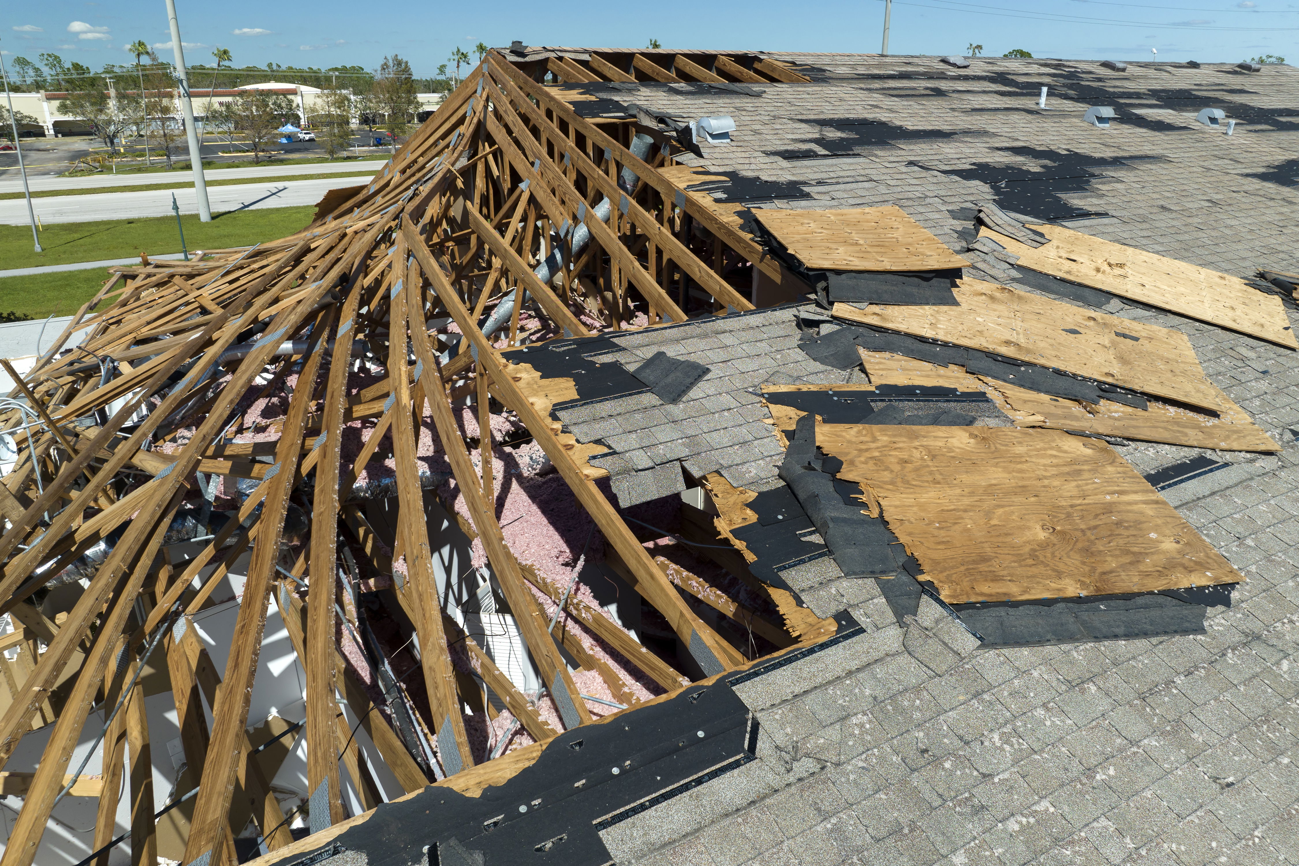
Traditional methods often miss important details. It's tough to get a full, overall view of the damage from the ground. Hidden problems, like subtle structural issues, often go unnoticed.Think about damage to roofs, high walls, or remote parts of a property. These areas are tough to see closely without specialized tools. This means claims might not include all the damage that truly happened.
How Aerial Documentation Enhances Claims
The Power of Drones and Aerial Photography
Aerial documentation uses advanced technology, mostly drones. These drones carry high-resolution cameras. They can fly over a property and capture incredibly detailed images and video.This technology offers more than just simple photos. It can create orthomosaic maps, which are perfectly stitched-together aerial images. Drones also generate 3D models and clear video footage. All this gives you a complete, high-definition view of any damage.
Comprehensive Damage Overview
Aerial views give a full picture of the damage. You can see the total impact across your entire property. Drones identify damage to many structures or outbuildings at the same time.They also document damage to surrounding areas. This includes landscaping or even neighboring properties affected by the event. It helps ensure every bit of related damage is seen and recorded.
Unbiased and Objective Evidence
One huge benefit of aerial documentation is its objectivity. It provides clear, undeniable visual proof of damage. This helps avoid arguments based on different views of what happened.The data collected is standard every time. This ensures consistent assessment, no matter who is looking at it. It brings a fair and factual basis to your claim.
Benefits for Policyholders
Faster and More Accurate Claims Processing
Aerial documentation speeds up the entire claim process. There's less need for many on-site visits from adjusters. You can submit comprehensive damage reports much quicker. This helps you move forward sooner.You gain powerful visual evidence from the very start. This puts you in a strong position. When filing a claim, ask your insurer about using or providing aerial documentation if you have it.
Increased Likelihood of Fair Compensation
Detailed documentation often leads to better claim outcomes. It makes sure all damage is seen and counted for. This stops insurers from underestimating repair costs because something was missed.A homeowner's roof was partly damaged, but the full extent was not clear from the ground. Aerial photos showed widespread shingle damage. This led to a much fuller payout for their claim. It helped them get what they truly needed.
Enhanced Communication and Transparency
Aerial data makes talking with insurers much better. You can share clear damage details with adjusters. Everyone gains a mutual understanding of the work needed. This makes the whole process smoother."Aerial imaging provides a shared, objective dataset that can significantly improve the transparency and efficiency of the claims adjustment process," says an industry expert. This shared view helps everyone.
Benefits for Insurance Companies
Improved Efficiency in Adjuster Workflows
Insurers gain a lot from this technology. It cuts down the time adjusters spend on first site checks. They can assess widespread damage remotely after big events. This means they can focus their efforts on the most complex cases.Reports show a big cut in claims processing time when aerial imagery is used. This makes the whole workflow much more effective. Adjusters can do more in less time.
Enhanced Risk Assessment and Fraud Detection
Aerial data also helps with managing risk. It allows for more accurate initial checks of properties. Insurers can verify what was damaged recently versus what was old damage.This technology also deters and helps catch fake claims. The visual data is verifiable and reliable. It makes it much harder for someone to make a dishonest claim.
Greater Accuracy in Estimating Repair Costs
Aerial data brings precision to cost estimates. It offers exact measurements of damaged areas. This leads to more accurate quotes for materials and labor. You get a detailed visual list of all damaged items.Insurers can use aerial data to build stronger models for repair costs. This ensures fairer and more precise estimates. It benefits both the company and the policyholder.
Implementing Aerial Documentation in Your Claims Process
When to Consider Aerial Documentation
Aerial documentation is most helpful in certain situations. It's a great choice after major storms, like hurricanes, tornadoes, or hail. It also works well for large property damage, like commercial buildings or many homes at once.If damage is on roofs, high structures, or hard-to-reach spots, drones are perfect. Use it when your first look at the damage doesn't give you a full picture.
Choosing a Service Provider
If you need drone services, pick wisely. Look for providers with proper certifications and insurance. Make sure they have good experience in property assessment. Ask what they deliver: images, videos, maps, or full reports.Ask potential providers for sample reports. Get references from their past work on insurance-related projects. This helps you find a reliable partner.
Working with Your Insurance Company
You can use aerial documentation to boost your claim. First, talk to your insurer about how to submit it. Understand what types of data they can accept or might even provide themselves.A business owner used drone footage after a disaster. It showed their premises were totally unusable. This strong evidence helped their business interruption claim greatly. It proved the extent of their loss.
Conclusion
Aerial documentation is a powerful tool. It greatly simplifies and improves the property damage insurance claims process. It helps people get back on their feet faster.This technology gives full, objective, and detailed visual proof. It ensures more accurate damage assessment. It also leads to fairer compensation for policyholders.Insurance companies benefit from being more efficient and getting better estimates. They also manage risk better through this advanced technology. This helps everyone involved. Embracing aerial documentation shows a smart, modern way to handle property claims. It builds trust and efficiency when you need it most.
SkyData is proud to support insurance professionals and property owners with reliable drone-based inspections and fast aerial reporting — helping turn damage into data, and stress into solutions.